

Project Portfolio
Survei Validasi Pemetaan Lahan gambut untuk Perencanaan Tata Air Landscape Kalimantan Barat
Kegiatan Survei Validasi Pemetaan Lahan Gambut bertujuan untuk memverifikasi dan meningkatkan akurasi peta sebaran dan kedalaman gambut melalui pengukuran langsung di lapangan.
Kegiatan Survei Validasi Pemetaan Lahan Gambut bertujuan untuk memverifikasi dan meningkatkan akurasi peta sebaran dan kedalaman gambut melalui pengukuran langsung di lapangan. Data hasil validasi berupa kedalaman gambut, muka air tanah, tutupan lahan, dan kondisi tata air eksisting akan digunakan sebagai dasar penyusunan Perencanaan Tata Air pada tingkat lanskap di Provinsi Kalimantan Barat. Hasil akhir diharapkan dapat mendukung upaya pencegahan kebakaran hutan dan lahan, restorasi gambut, serta pengelolaan sumber daya air berkelanjutan
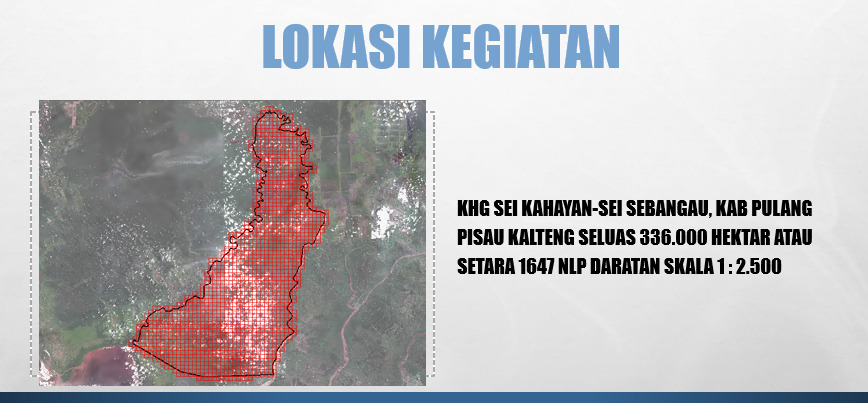
Akuisisi Data dan Pemetaan Gambut di Wilayah Kabupaten Pulang Pisau, Provinsi Kalimantan Tengah
Kegiatan Akuisisi Data dan Pemetaan Tematik di Wilayah Kabupaten Pulang Pisau bertujuan untuk menyediakan data spasial dan informasi tematik yang akurat sebagai dasar perencanaan pembangunan dan pengelolaan sumber daya wilayah.
Kegiatan Akuisisi Data dan Pemetaan Tematik di Wilayah Kabupaten Pulang Pisau bertujuan untuk menyediakan data spasial dan informasi tematik yang akurat sebagai dasar perencanaan pembangunan dan pengelolaan sumber daya wilayah. Ruang lingkup meliputi akuisisi data LiDAR, foto udara, dan data lapangan, survey pasang surut, dilanjutkan dengan pengolahan dan analisis untuk menghasilkan peta tematik seperti peta lahan gambut, tutupan lahan, rawan banjir, dan potensi wilayah. Hasil kegiatan diharapkan dapat mendukung penyusunan kebijakan tata ruang, mitigasi bencana, dan pembangunan berkelanjutan di Kabupaten Pulang Pisau.
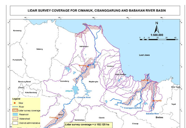
Lidar And Digital Aerial Photography Acquisition Under Preparation of Cimanuk Cisanggarung River Basin Flood Management Projects in West and Central Java Province, Accelerating Infrastructure Delivery Through Better Engineering Service Project (ESP), ADB Loan No. 3455-INO
Kegiatan adalah untuk memperoleh data spasial 3 dimensi resolusi tinggi berupa data LiDAR dan foto udara di wilayah DAS Cimanuk dan DAS Cisanggarung
Kegiatan Lidar and Digital Aerial Photography Acquisition merupakan bagian dari Preparation of Cimanuk Cisanggarung River Basin Flood Management Projects dalam lingkup Accelerating Infrastructure Delivery Through Better Engineering Service Project yang dibiayai ADB Loan No. 3455-INO. Tujuan kegiatan adalah untuk memperoleh data spasial 3 dimensi resolusi tinggi berupa data LiDAR dan foto udara di wilayah DAS Cimanuk dan DAS Cisanggarung. Data tersebut akan digunakan sebagai dasar perencanaan, pemodelan hidrolika, dan Detail Engineering Design infrastruktur pengendalian banjir guna mengurangi risiko bencana banjir di Provinsi Jawa Barat dan Jawa Tengah.
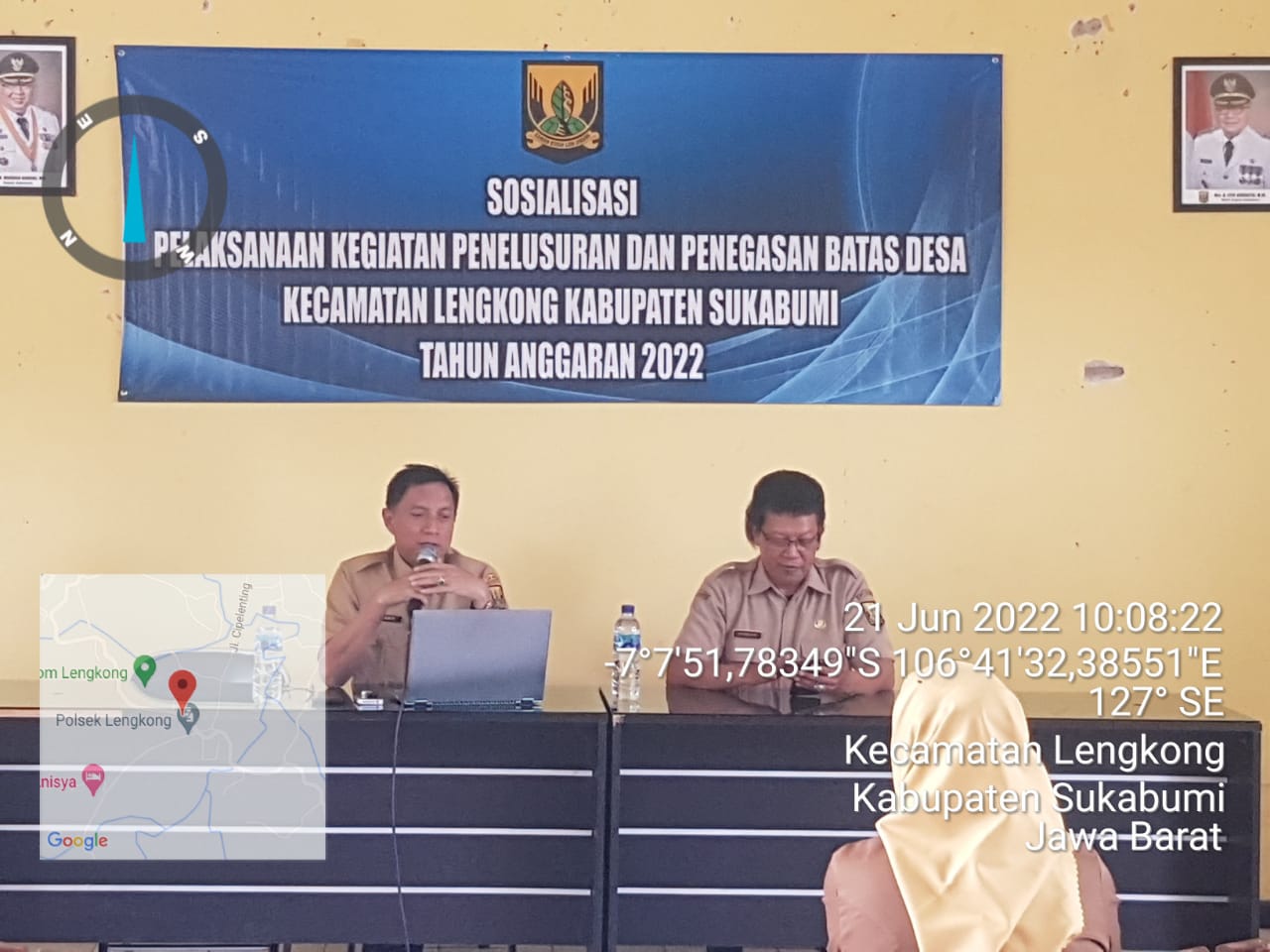
Kegiatan Penelusuran dan Penegasan Batas Desa- Kabupaten Sukabumi
Kegiatan Penelusuran dan Penegasan Batas Desa di Kabupaten Sukabumi bertujuan untuk memberikan kepastian hukum atas batas wilayah desa
Kegiatan Penelusuran dan Penegasan Batas Desa di Kabupaten Sukabumi bertujuan untuk memberikan kepastian hukum atas batas wilayah desa. Ruang lingkup kegiatan meliputi penelusuran dokumen dan kesepakatan historis, pengumpulan data spasial, pengukuran dan penegasan batas di lapangan, pemasangan pilar batas, serta pembuatan peta dan berita acara kesepakatan. Hasil kegiatan ini diharapkan dapat meminimalisir potensi konflik batas wilayah dan menjadi dasar dalam perencanaan pembangunan, penataan administrasi pemerintahan, dan pelayanan publik di Kabupaten Sukabumi.
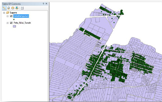
Consulting Service For Application Development Of Parcel-Based Mass Land Valuation Phase 3
Pengembangkan sistem aplikasi yang mampu melakukan penilaian massal nilai tanah berbasis bidang secara otomatis dan berkelanjutan
Kegiatan Consulting Service For Application Development Of Parcel-Based Mass Land Valuation Phase 3 bertujuan untuk mengembangkan sistem aplikasi yang mampu melakukan penilaian massal nilai tanah berbasis bidang secara otomatis dan berkelanjutan. Aplikasi ini mengintegrasikan data spasial bidang tanah dengan data pasar dan atribut lainnya untuk menghasilkan estimasi nilai pasar per bidang. Hasil dari sistem ini akan digunakan sebagai dasar penyempurnaan Zona Nilai Tanah, penetapan NJOP, dan mendukung kebijakan pertanahan lainnya guna mewujudkan kepastian hukum dan keadilan ekonomi pertanahan
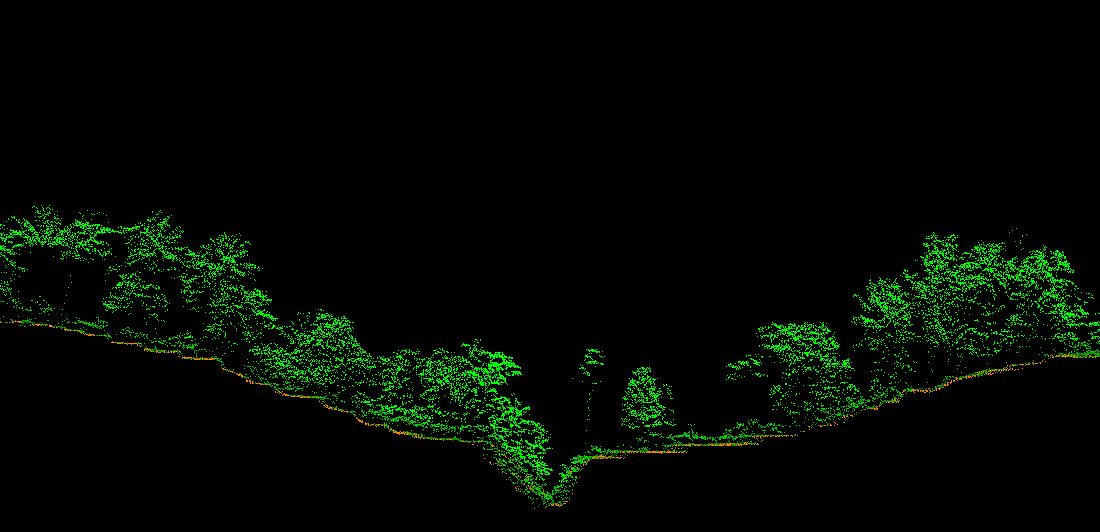
Pengambilan Data Lidar dan Foto Udara Berau , Kalimantan Timur
Kegiatan Pengambilan Data LiDAR dan Foto Udara bertujuan untuk menyediakan data spasial 3 dimensi resolusi tinggi sebagai dasar manajemen tata kelola wilayah dan perhitungan potensi perdagangan karbon.
Kegiatan Pengambilan Data LiDAR dan Foto Udara bertujuan untuk menyediakan data spasial 3 dimensi resolusi tinggi sebagai dasar manajemen tata kelola wilayah dan perhitungan potensi perdagangan karbon. Data LiDAR digunakan untuk menghasilkan model permukaan, estimasi biomassa, dan volume tegakan, sedangkan foto udara digunakan untuk pemetaan tutupan lahan. Hasil integrasi kedua data tersebut akan digunakan sebagai dasar perhitungan cadangan karbon dan pemantauan perubahan tutupan lahan dalam rangka mendukung implementasi carbon trade dan tata kelola sumber daya hutan yang berkelanjutan.
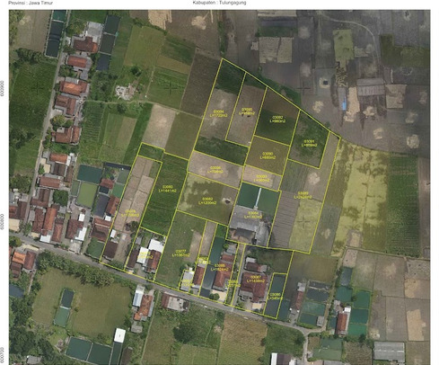
Pengukuran, Pemetaan dan Informasi Bidang Tanah Pendaftaran Tanah Sistematis Lengkap Berbasis Partisipasi Masyarakat Kantor Pertanahan Kabupaten Tulungagung (10,000 Bidang)
Kegiatan Pengukuran, Pemetaan dan Informasi Bidang Tanah Pendaftaran Tanah Sistematis Lengkap Berbasis Partisipasi Masyarakat di Wilayah Kerja Kantor Pertanahan Kabupaten Tulungagung dengan target 10.000 bidang bertujuan untuk mempercepat penyelesaian sertifikasi tanah milik masyarakat.
Kegiatan Pengukuran, Pemetaan dan Informasi Bidang Tanah Pendaftaran Tanah Sistematis Lengkap Berbasis Partisipasi Masyarakat di Wilayah Kerja Kantor Pertanahan Kabupaten Tulungagung dengan target 10.000 bidang bertujuan untuk mempercepat penyelesaian sertifikasi tanah milik masyarakat. Ruang lingkup meliputi pengumpulan data yuridis dan fisik, pengukuran dan pemetaan bidang tanah, serta penerbitan informasi pertanahan dengan melibatkan partisipasi aktif masyarakat melalui Kelompok Masyarakat. Hasil kegiatan berupa data bidang tanah yang telah diumumkan, diinput dalam SIMTANAH, dan menjadi dasar penerbitan sertifikat tanah sebagai wujud kepastian hukum hak atas tanah
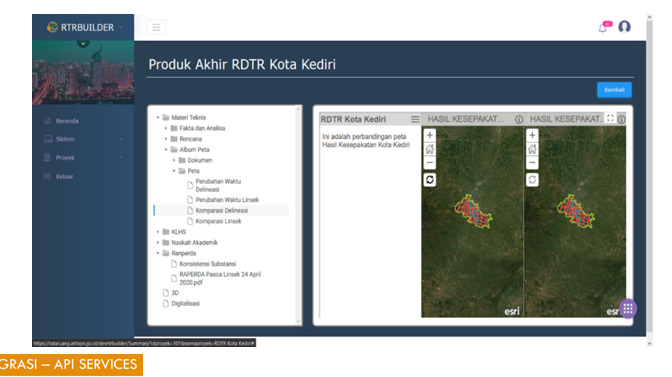
Pengembangan Aplikasi RTR Builder
Kegiatan Pengembangan Aplikasi RTR Builder bertujuan untuk menyediakan platform berbasis WebGIS yang dapat digunakan oleh pemerintah pusat dan daerah dalam penyusunan dokumen Rencana Tata Ruang.
Kegiatan Pengembangan Aplikasi RTR Builder bertujuan untuk menyediakan platform berbasis WebGIS yang dapat digunakan oleh pemerintah pusat dan daerah dalam penyusunan dokumen Rencana Tata Ruang. Aplikasi ini dilengkapi modul perancangan zonasi, validasi aturan tata ruang, dan generator otomatis untuk peta dan dokumen teknis sesuai peraturan perundang-undangan. Dengan RTR Builder, proses penyusunan RDTR dan RTRW diharapkan lebih cepat, akurat, akuntabel, serta terintegrasi langsung dengan sistem OSS dan SIMTANAH guna mendukung percepatan pelayanan perizinan berbasis kesesuaian tata ruang.
Pengembangan Sistem Integrasi Metadata dan Modul Verifikasi Katalog Data Hulu Migas Berbasis Interkoneksi GIS
Kegiatan Pengembangan Sistem Integrasi Metadata dan Modul Verifikasi Katalog Data Hulu Migas Berbasis Interkoneksi GIS
Kegiatan Pengembangan Sistem Integrasi Metadata dan Modul Verifikasi Katalog Data Hulu Migas Berbasis Interkoneksi GIS bertujuan untuk menyediakan satu sistem terpusat dalam pengelolaan data dan metadata kegiatan usaha hulu minyak dan gas bumi. Sistem ini mengintegrasikan data dari Kontraktor Kontrak Kerjasama ke dalam Katalog Data Nasional, dilengkapi modul verifikasi otomatis untuk memastikan kualitas dan kesesuaian data. Seluruh data yang telah terverifikasi akan diinterkoneksikan dengan platform GIS sehingga dapat divisualisasikan secara spasial dan dimanfaatkan sebagai dasar pengambilan keputusan, monitoring, dan pelaporan kinerja hulu migas oleh SKK Miga
Pengembangan Decision Support System Kehutanan
pekerjaan meliputi pengumpulan dan integrasi data kehutanan, pengembangan modul analisis kerawanan kebakaran hutan, deforestasi, potensi konflik tenurial, serta penyusunan dashboard berbasis WebGIS.
Kegiatan Pengembangan Decision Support System Kehutanan merupakan upaya penyediaan sistem informasi berbasis spasial dan analisis data untuk mendukung pengambilan keputusan pengelolaan hutan yang efektif, efisien, dan akuntabel. Ruang lingkup pekerjaan meliputi pengumpulan dan integrasi data kehutanan, pengembangan modul analisis kerawanan kebakaran hutan, deforestasi, potensi konflik tenurial, serta penyusunan dashboard berbasis WebGIS. Sistem yang dikembangkan akan digunakan oleh pemangku kebijakan di lingkup Kementerian Kehutanan dan UPT dalam perencanaan, monitoring, dan evaluasi program kehutanan secara real-time dan berbasis kondisi terkini dilapangan.
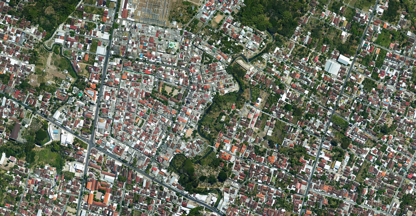
Pembuatan Peta Foto Tegak Menggunakan Pesawat Udara Nirawak (PUNA) Kantor Pertanahan Kabupaten Madiun (35,021 Hektar)
egiatan Pembuatan Peta Foto Tegak Menggunakan Pesawat Udara Nirawak di Wilayah Kerja Kantor Pertanahan Kabupaten Madiun dengan target luasan 35.021 Hektar merupakan upaya penyediaan data dasar pertanahan yang akurat dan mutakhir
Kegiatan Pembuatan Peta Foto Tegak Menggunakan Pesawat Udara Nirawak di Wilayah Kerja Kantor Pertanahan Kabupaten Madiun dengan target luasan 35.021 Hektar merupakan upaya penyediaan data dasar pertanahan yang akurat dan mutakhir dalam rangka mendukung pelaksanaan Pendaftaran Tanah Sistematis Lengkap Terintegrasi pada Integrated Land Administration and Spatial Planning Project. Ruang lingkup pekerjaan meliputi perencanaan terbang, akuisisi foto udara, pengukuran Ground Control Point, pengolahan data fotogrametri, dan penyusunan orthophoto yang telah terkoreksi geometrik. Hasil kegiatan berupa Peta Foto Tegak dengan resolusi spasial 10 cm - 20 cm akan digunakan sebagai dasar pemetaan bidang tanah, penegasan batas, serta integrasi data spasial pertanahan ke dalam sistem administrasi pertanahan nasional.
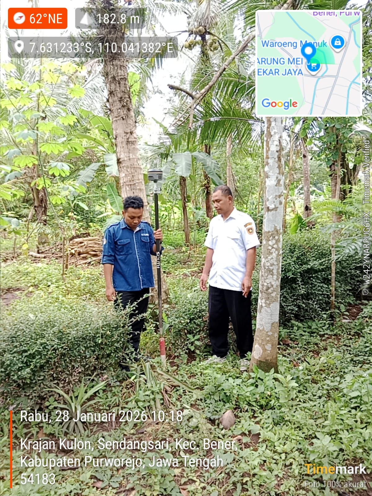
Pengukuran, Pemetaan dan Informasi bidang tanah pendaftaran tanah sistematis lengkap (PTSL) Terintegrasi pada Integratred Land Administration and spasial planing project (ILLASP) Kantor Pertanahan Kabupaten Purworejo (12,000 Ha)
Kegiatan Pengukuran, Pemetaan dan Informasi bidang tanah dalam rangka Pendaftaran Tanah Sistematis Lengkap Terintegrasi pada Integrated Land Administration and Spatial Planning Project di Kantor Pertanahan Kabupaten Purworejo
Kegiatan Pengukuran, Pemetaan dan Informasi bidang tanah dalam rangka Pendaftaran Tanah Sistematis Lengkap Terintegrasi pada Integrated Land Administration and Spatial Planning Project di Kantor Pertanahan Kabupaten Purworejo merupakan upaya percepatan pendaftaran tanah secara massal dengan target luasan 12.000 Ha. Ruang lingkup pekerjaan meliputi pengumpulan data yuridis, pengukuran dan pemetaan bidang tanah, serta penyajian informasi pertanahan. Seluruh data hasil kegiatan akan diintegrasikan ke dalam sistem administrasi pertanahan nasional guna mewujudkan kepastian hukum hak atas tanah bagi masyarakat dan mendukung keterpaduan data pertanahan dengan rencana tata ruang wilayah.


